What Is Some of the Best Evidence for the Global Flood? Part 2
Introduction
In our last post we asked the question: If the flood described in Genesis 7-8 really happened, then what would we expect to find? We would find billions of dead things buried in mud, sand, and lime in sedimentary rock layers all over the world.
And that’s exactly what we find. On a spectacular, global scale.
Last time, we looked at three compelling evidences for the Genesis flood: Exquisitely preserved fossils, marine fossils high up in the mountains, and massive fossil graveyards all around the world. In this post, we will continue with four more powerful evidences for the global flood.[1]
4. Sediment Spread Across Continents
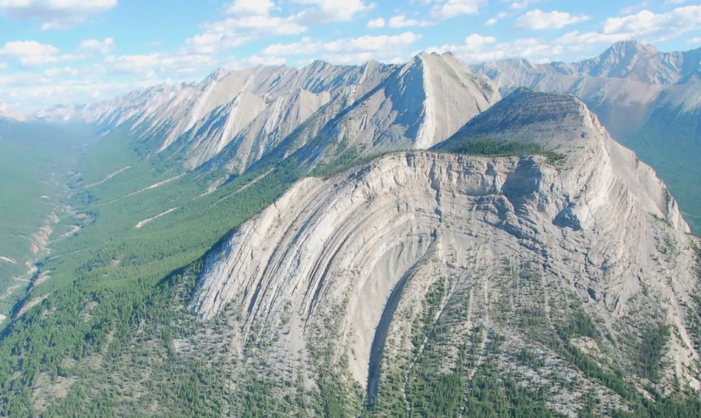
On every continent, we find sedimentary rock layers that must have been put down by extreme, catastrophic conditions because those layers cover huge areas. Many of them can be traced across whole continents and even between continents.
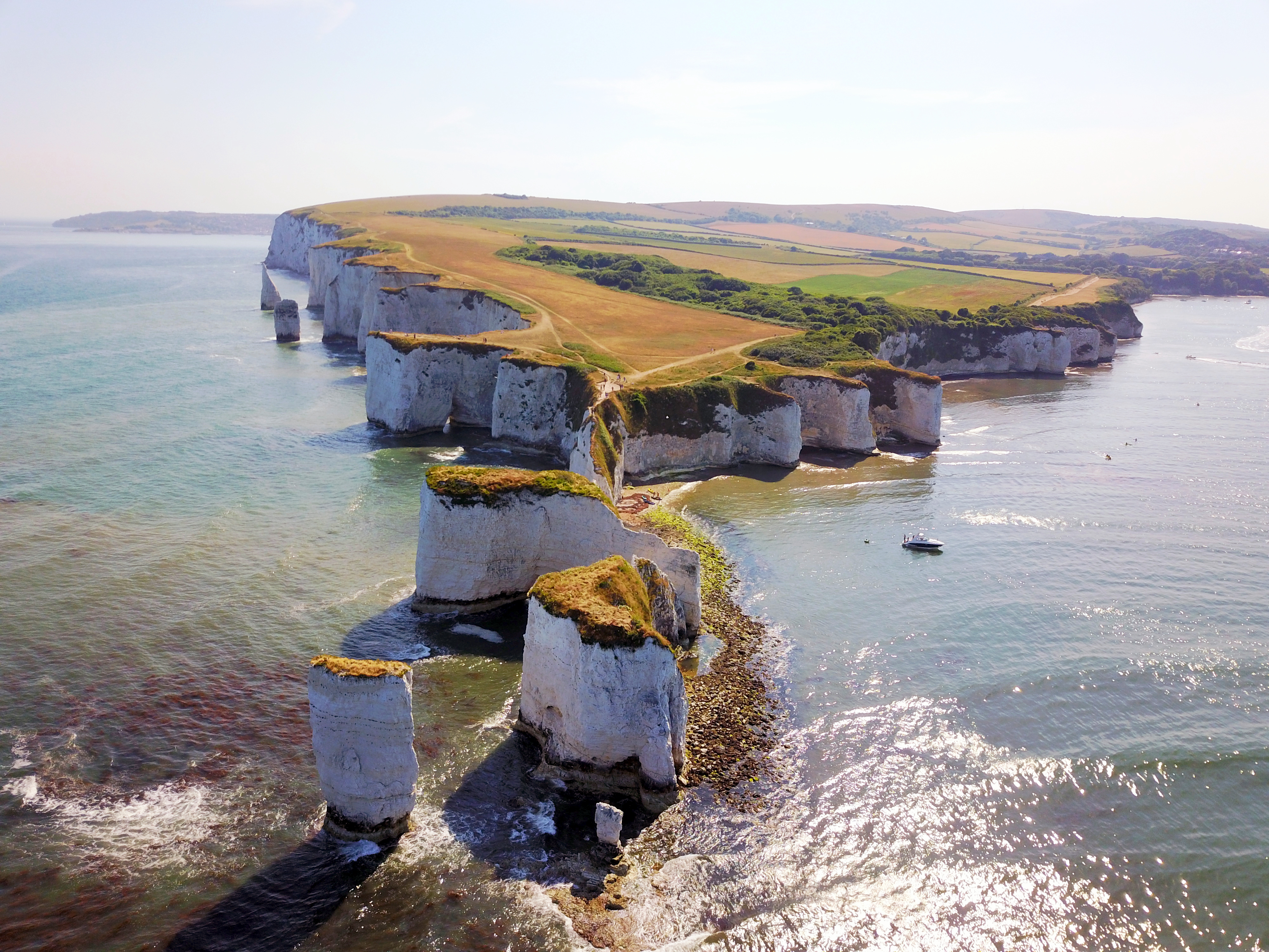
For example, the Cetaceous chalk beds of southern England, known as the beautiful white cliffs of Dover, can be traced to the north and west across England up into Northern Ireland. In the opposite direction, the same chalk beds can be traced across France, the Netherlands, Germany, Poland, southern Scandinavia, and other parts of Europe to Turkey; then to Israel and Egypt, and as far as Kazakhstan. Remarkably the same chalk beds, with the same fossils and the same distinctive layers above and below them, are also found in the Midwest USA from Nebraska to Texas, and from Alabama and Arkansas to Colorado. They also appear in the Perth Basin of Western Australia.
Likewise, the sedimentary rock layers exposed in the Grand Canyon are not unique to that area. The Tapeats Sandstone, for example, extends from the Grand Canyon and covers much of the United States, parts of Canada, and Greenland. Its equivalents, that is layers at the same level and comprised of the same materials, can traced across north Africa and beyond to Israel, Jordan, and Saudi Arabia.
What is the origin of these continental scale sedimentary layers, which by the way, contain fossils of organisms that were rapidly buried? Only the ocean waters rising to sweep across the continents in the global food could have done this.
5. Features of the Sedimentary Layers
When we take a closer look at some of the sedimentary rock layers, we see features that clearly show high energy, even violent, water deposition.
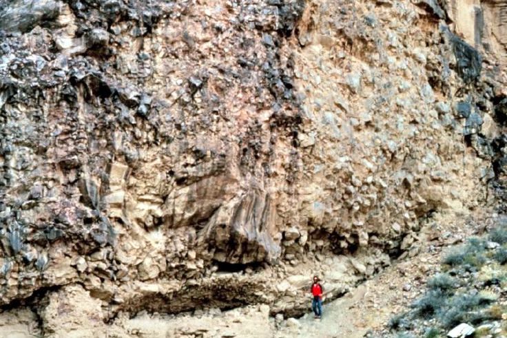
For example, we see huge boulders at the bottom of the Tapeats Sandstone layer, mentioned earlier, along with beds of sand that was eroded from the hard, underlying crystalline rocks. Violent storms with massive forces would have been responsible for depositing this material rapidly, and to wherever that layer extends; again, across the entire United States and beyond, across North Africa and into the Middle East. Today’s slow and gradual processes can not explain this kind of catastrophic deposition, but the global flood can.
The strength of the flood is also evident in the buff colored Coconino Sandstone layer found near the top of the Grand Canyon. On average, this layer is 315 feet thick and covers an area of almost 930,000 square miles, extending from Mexico to Canada. The volume of sand in this layer is about 55,000 cubic miles.
Interesting, angled cross bed layers can be found within the Coconino Sandstone. One possible explanation is that they are remnants of sand waves produced by the water currents that deposited the sand; like sand dunes, but underwater. It can be demonstrated that water, flowing at 3-5 miles per hour, deposited the Coconino Sandstone as massive sheets of sand, with sand waves up to 60 feet high. At this rate, the whole layer would have been deposited in just a few days.
6. No Sign of Millions of Years Between Layers
If the sedimentary layers took hundreds of millions of years to accumulate at today’s slow rates, then the boundaries between many of the layers should be broken by a lot of varied topography. We should see weathered surfaces from millions of years of wear and erosion after each layer was deposited. On the other hand, given the catastrophic conditions of the global flood, even if land surfaces were briefly exposed, any erosion would have been rapid and widespread. This would leave behind flat and smooth surfaces, which is what we see.
At the boundaries between some sedimentary layers, we find evidence of only rapid erosion. In most other cases, the boundaries are flat and featureless with absolutely no evidence of any erosion at all. This would be consistent with the global flood, because there would have been no long periods of elapsed time. Consider examples of each case.
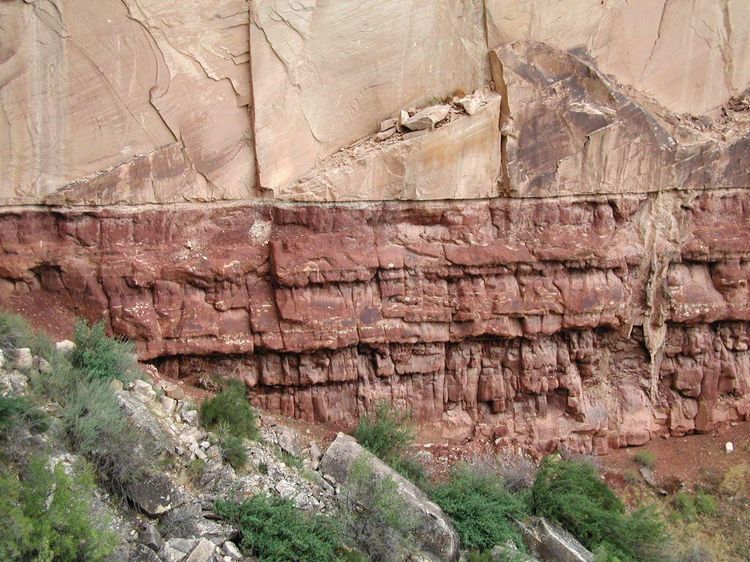
The layers below the Grand Canyon’s Tapeats Sandstone were rapidly eroded and then extensively scraped flat, or planed off. This powerful erosion occurred on a massive scale because, again, we see its effects wherever the Tapeats and is equivalents are found—across North America, Africa, and into the Middle East. Many different underlying rock layers were affected, such as granites, metamorphic rocks, and tilted sedimentary layers. We know this large-scale erosion was rapid because we find no evidence of longer-term weathering under boundary.
On the other hand, we have the boundary between the Coconino Sandstone and the Hermit Formation under it. This boundary is similarly flat, featureless, and knife-edged from one end of the Grand Canyon to the other. But there is absolutely no evidence of any erosion of the Hermit Formation at all, before the Coconino Sandstone was deposited. Millions of years between the layers is simply missing; clear evidence that the layers were put down in rapid succession.
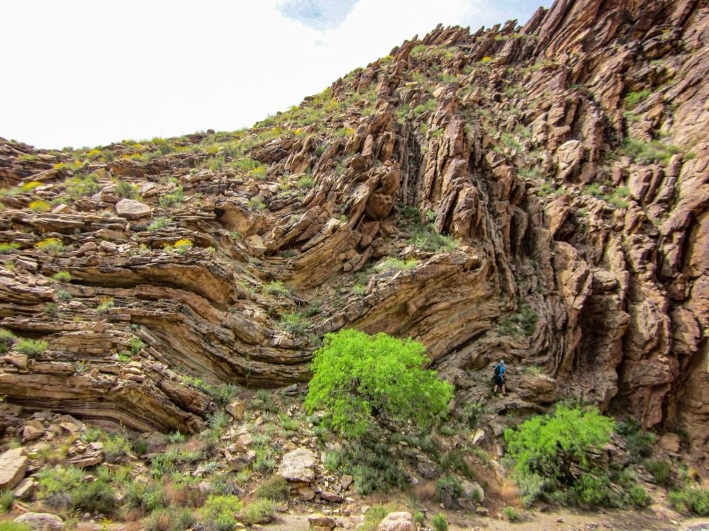
7. Tightly Folded Rock Layers
Tightly folded rock layers are evidence that those layers were put down quickly. When hard rock is bent or folded, it fractures and breaks because it is brittle. When we see folded layers that are not like this, then it means the layers were bent while they were still soft and pliable, like modeling clay.
When water deposits sediment in a layer, some water remains trapped between the sediment grains. As other layers are laid down on top, the pressure squeezes the grains closer together and forces out much of the water. As the layer dries out, the chemicals that were in the water between the grains convert into a natural cement. This cement transforms the originally soft and wet sediment into hard, brittle rock. This process generally takes days or months, but can also happen in hours depending on the conditions.
The entire 4,500 foot sequence of sedimentary layers at the Grand Canyon is well above sea level. In the past, earth movement pushed all these layers up to form the Kaibab Plateau. But toward the east, they were not pushed up as high, and the whole sequence is about 2,500 feet lower than the Kaibab Plateau. The boundary between the Kaibab Plateau and the less uplifted eastern region is marked by a large step-like fold called the East Kaibab Monocline.
These folded layers are visible in several different canyons. For example, we see the Tapeats Sandstone in Carbon Canyon, where layers are bent at 90 degrees. But the rock is not fractured or broken, as what would be expected with ancient brittle rocks. All the layers above the Tapeats Sandstone are similarly folded.
The conventional explanation is that under the pressure and heat of burial, the hardened layers were bent so slowly that they behaved as though they were plastic, so they didn’t break. But pressure and heat would have caused changes in the textures and minerals in the rocks that we would be able to detect today. We don’t see these changes. The only logical conclusion is that the whole sequence of layers was put down in rapid succession in just a few months during the early stages of the flood. This was followed by the uplift of the Kaibab Plateau at the end of the flood only months later, when the sediments were still soft and pliable.
Conclusion
During the Enlightenment period, starting in the 1700s and going into the 1800s, philosophers worked very hard to try to explain the world without any need for God. Atheist geologists like Charles Lyell advanced arguments for uniformitarianism, that present forces could be responsible for shaping the earth in the past, given billions of years.
But these arguments were not so much about examining the evidence, rather, justifying an atheistic world view, and trying to show how the evidence can fit. Unfortunately, uniformitarianism is the prevailing foundational belief in geology to this day. But what if it’s wrong? Is there room for catastrophe?
A closer look the evidence says yes. The rock layers give us powerful evidence of massive catastrophe on a global scale, clearly in harmony with the Genesis account of the flood. What does this mean? It means that we can take God at his word. The evidence continues to affirm the Biblical world view, as derived from Genesis and the rest of the Bible.
[1] This post is adapted from Dr. Andrew Snelling, “Global Evidences of the Genesis Flood” Answers Magazine, July-September 2021, Vol. 16 No. 3; also from the on-line article “What Are Some of the Best Flood Evidences,” available at https://answersingenesis.org/the-flood/what-are-some-of-the-best-flood-evidences/, along with all of its technical references, accessed 10/5/21.